Corpis Maps 4.1 has been released. This page summarizes the major features and improvements of the release, and provides links to additional information or live demos.
“In the latest version of Corpis Maps, we primarily focused on the support of sales potential analyses, which will help you to target their sales activities in the right locations. We added new features in order to make Corpis Maps easier to use when it is integrated with software products of our partners. Corpis Maps help businesses to increase the efficiency of sales activities and identify localities with the highest sales potential. Our analytical maps play a key role in decision making processes in businesses of any size.”, said Jaroslav Polacek, Corpis Maps Product and Partnership Manager.

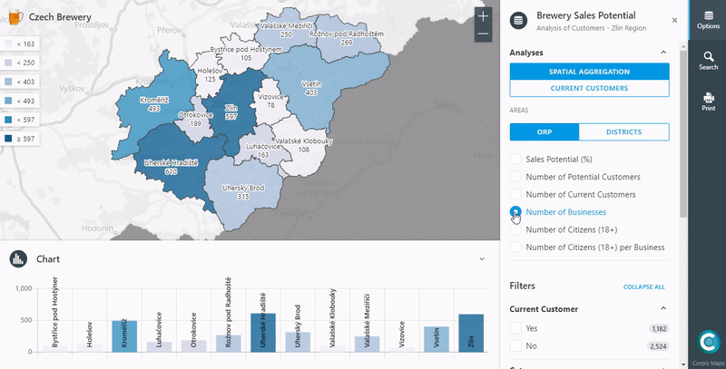
External Data Support (GeoEnrichment)
You can now add any statistical data (e.g. number of citizens in a particular age category, unemployment rate, purchase power, number of potential customers) or any other data from external analytical sources (e.g. sales performance of your competitors) to the map for aggregation analysis in polygons.
CSV and JSON formats are supported. This data can be easily added to Corpis Maps, you can use it in formulas together with your business data (e.g. number of 18+ year old citizens per a restaurant) and show the results in the analytical map. It is easy and very very useful. Try it out in the demo map below.
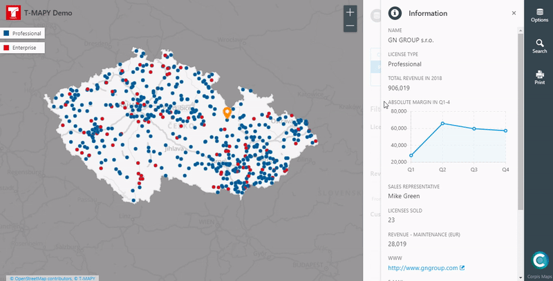
Slider or a chart from values calculated in Corpis Maps
Corpis Maps supports formulas, so you can easily create new calculated fields from source data. Now you can use calculated fields to create a chart in the Info panel and for a slider in visualizations. Example: Absolute Margin in Q1-4 (Price – Total Cost).
Possibility to close the Control panel
Control panel, which contains various visualizations and analytical filters, can now be closed by a user to get more space for the map. You will appreciate this option if you are going to integrate Corpis Maps into a web application or a web portal.
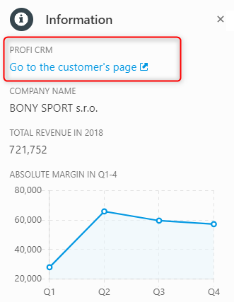
URL link behaviour
If you have a link to a website in the Info panel, you can now choose where the website will be open, if a user click on it (e.g. in the same window, new window, etc.). By default, the website appers in the new window, which is suitable for most of the users. This feature has been primarily created for integrations with CRM, ERP, E-commerce and other systems.
Other Improvements and Enhancements
Corpis Maps Creator (visual and functional enhancements), new strings added to the Locale section, mobile version (visual and functional enhancements), performance increase, search improvements, charts (visual and functional enhancements) in the Info panel.
Availability
All Corpis Maps Integration Partners, Solution Partners and clients have immediate access to this new version.
Are you interested in a Corpis Maps demo map containing your own data?
Would you like to integrate Corpis Maps into your product (CRM, ERP, E-commerce, …)?